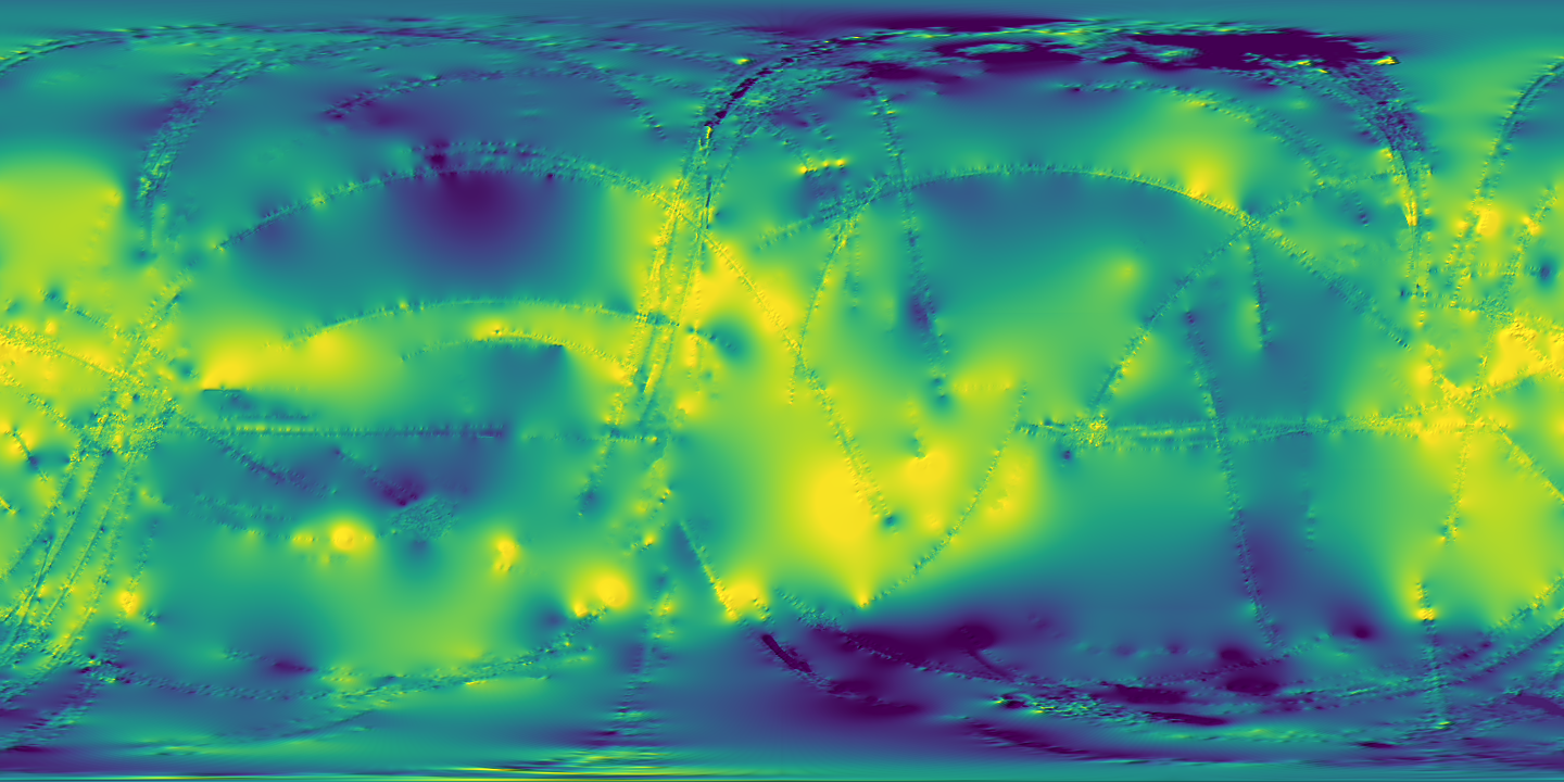
Global height maps of Titan that combine every Cassini topography source, ready to open as map layers.
In plain words
These are global elevation maps of Titan built from all the topography Cassini collected: radar altimetry, SARtopo and stereo images. Real measurements cover only about 9 percent of Titan, so the gaps are filled by interpolation. The files are map-projected ISIS3 cubes, so GIS software can place them on Titan without extra georeferencing. Start with the 4 MB global map if you want something small.
Good for: measure heights and slopes; make a map of a region for a class project.
The details
What is inside
Five ISIS3 cubes. Three are global grids at 32 pixels per degree, each 253 MB: alt_32PPD.cub, dtm_32PPD.cub and sar_32PPD.cub. The names point to altimetry, stereo DTM and SARtopo inputs; the folder has no readme that confirms this. Two are global grids at 4 pixels per degree, each 4.0 MB: topo_4PPD.cub and topo_4PPD_interp.cub. The download zip is 27.5 MB.
How it was made
Corlies et al. (2017) gathered every altimetry, SARtopo and stereophotogrammetry height measurement from the Cassini mission. These cover about 9 percent of Titan's surface. They then filled the gaps with radial basis function interpolation and corrected biases profile by profile. The paper also reports a flatter Titan than earlier measured and new topographic rises in the southern hemisphere.
Resolution and coverage
All five cubes cover the whole globe, -180 to 180 degrees longitude and -90 to 90 degrees latitude, in a simple cylindrical (equirectangular) projection on a sphere of radius 2,575 km. The 32 pixel-per-degree grids are 11,520 by 5,760 pixels, about 1.4 km per pixel at the equator. The 4 pixel-per-degree grids are 1,440 by 720 pixels, about 11.2 km per pixel. Values are 32-bit floating point. GDAL 3.12.2 reads topo_4PPD.cub with its Titan coordinate system embedded.
How to cite
Cite the paper, Corlies et al. (2017), Geophysical Research Letters 44, https://doi.org/10.1002/2017GL075518, and the dataset, Corlies and Hayes (2024), Cornell University eCommons, https://doi.org/10.7298/m4dv-gv95. The eCommons record releases the data under CC0 1.0.
Open it in your GIS
ArcGIS Pro
Opens directlyOpens as it is downloaded.
Download titan_topo_corlies.zip (27.5 MB) from the Hayes Research Group data products page.
Extract the zip into one folder.
Open ArcGIS Pro and create a new project with a map.
On the Map tab, in the Layer group, click Add Data, then click Browse.
Select topo_4PPD.cub and click OK.
Right-click the map in the Contents pane and click Properties.
Click the Coordinate Systems tab and confirm the map uses the Titan system from the layer.
Right-click the layer and click Symbology to choose a color scheme for elevation.
Add dtm_32PPD.cub or another 32 pixel-per-degree grid when you need more detail.
Titan is a sphere of radius 2,575 km. Do not let ArcGIS Pro treat the map as Earth (WGS 1984).
The cubes carry their own Titan coordinate system. If you need to pick one, search for Titan 2000 (Esri WKID 104943) under the Solar System geographic coordinate systems.
Esri lists ISIS cubes (versions 2 and 3) as read-only, with 8-bit unsigned and 32-bit float data. These cubes are 32-bit float.
Measured heights cover only about 9 percent of Titan. The rest is interpolated, so treat gaps with care.
A ready-made GeoTIFF of topo_4PPD is on this site's Titan topography sample page.
QGIS
Opens directlyOpens as it is downloaded.
Download titan_topo_corlies.zip and extract it into one folder.
Select Layer > Add Layer > Add Raster Layer.
Select topo_4PPD.cub and click Add.
Open Layer Properties, click the Source tab and check the CRS is Equirectangular Titan.
Right-click the layer and select Layer CRS > Set Project CRS from Layer.
Open Layer Properties, click Symbology and select Singleband pseudocolor.
Select a color ramp and click OK.
Add dtm_32PPD.cub or another 32 pixel-per-degree grid when you need more detail.
Titan is a sphere of radius 2,575 km. Do not assign EPSG:4326 (WGS 84); use the CRS embedded in the cube.
If you need a Titan CRS by hand, select Settings > Custom CRS (Custom Projections in older versions) and paste the WKT from the layer's Source tab.
PROJ also defines IAU_2015:60600 for the Titan sphere. Your QGIS version may or may not list it.
Measured heights cover only about 9 percent of Titan. The rest is interpolated.
JMARS
Not confirmedNobody has confirmed this tool opens it yet.
Select Titan in the JMARS body list, if your version offers it.
Download titan_topo_corlies.zip and extract it into one folder.
Click Add New Layer, then click Advanced Map.
Click Upload Map in the Available Maps section.
Enter the path to topo_4PPD.cub, then type a name for the map.
Select global as the map type.
Type an ignore value for blank pixels if the cube has them.
JMARS support for Titan is not confirmed. The JMARS FAQ lists a Titan radius of 2,576 km, but no JMARS page we found confirms Titan as a selectable body.
JMARS custom maps accept ISIS cub files up to 512 MB. All five cubes are under that limit (253 MB or less).
JMARS reads the position of an ISIS cube from the file, so you do not type a bounding box.
A PNG with a world file is also on this site's Titan topography sample page.
The converted sample uses Titan 2015 sphere (radius 2,575 km), planetocentric latitude, east-positive longitude, plate carree in degrees (IAU_2015:60600), which treats Titan as a sphere of radius 2,575 km. Longitude runs from -180 to 180, positive east. Keep that coordinate system; do not reproject to an Earth one.
Converted sample
Small files converted for this site so you can try the data before downloading all of it. See it on the map.
Titan global topography (Corlies et al. 2017), 4 pixels per degree
GEOGCRS["Titan (2015) - Sphere / Ocentric",DATUM["Titan (2015) - Sphere",ELLIPSOID["Titan (2015) - Sphere",2575000,0,LENGTHUNIT["metre",1]]],PRIMEM["Reference Meridian",0,ANGLEUNIT["degree",0.0174532925199433]],CS[ellipsoidal,2],AXIS["geodetic latitude (Lat)",north,ORDER[1],ANGLEUNIT["degree",0.0174532925199433]],AXIS["geodetic longitude (Lon)",east,ORDER[2],ANGLEUNIT["degree",0.0174532925199433]],ID["IAU",60600,2015],REMARK["Use mean radius as sphere radius for interoperability. Source of IAU Coordinate systems: https://doi.org/10.1007/s10569-017-9805-5"]]
GDAL reads the GeoTIFF CRS as a geographic CRS on a 2,575,000 m sphere (Titan 2015) with east-positive longitude (tools/spatial/verify.py).
GDAL reads bounds -180, -90, 180, 90 and 0.25 degree pixels, 1440 by 720.
Every elevation value is within 10 km of the reference sphere; nodata is set.
COG layout: tiled 256 by 256, DEFLATE, with internal overviews; GDAL reports LAYOUT=COG.
GDAL reads the PNG with its world file and .prj at the same bounds and CRS.
Every file listed here exists with the byte size shown.
Converted from topo_4PPD_interp.cub (and topo_4PPD.cub for the measured-only file), https://data.astro.cornell.edu/titan_topo_corlies/full_dataset/, with rasterio 1.5.2 / GDAL 3.12.2 on 2026-10-07 by tools/spatial/titan_topo.py. Data CC0 1.0, credit Paul Corlies, Corlies et al. 2017, doi:10.7298/m4dv-gv95.