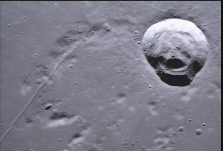
The Titan samples only needed a format change. A raw camera frame needs more: it has no coordinates until you give it some. Here is one frame from the GRAIL MoonKAM cameras, tied to a reference map of the Moon by hand.
ApproximateMoon, sphere of radius 1,737.4 km
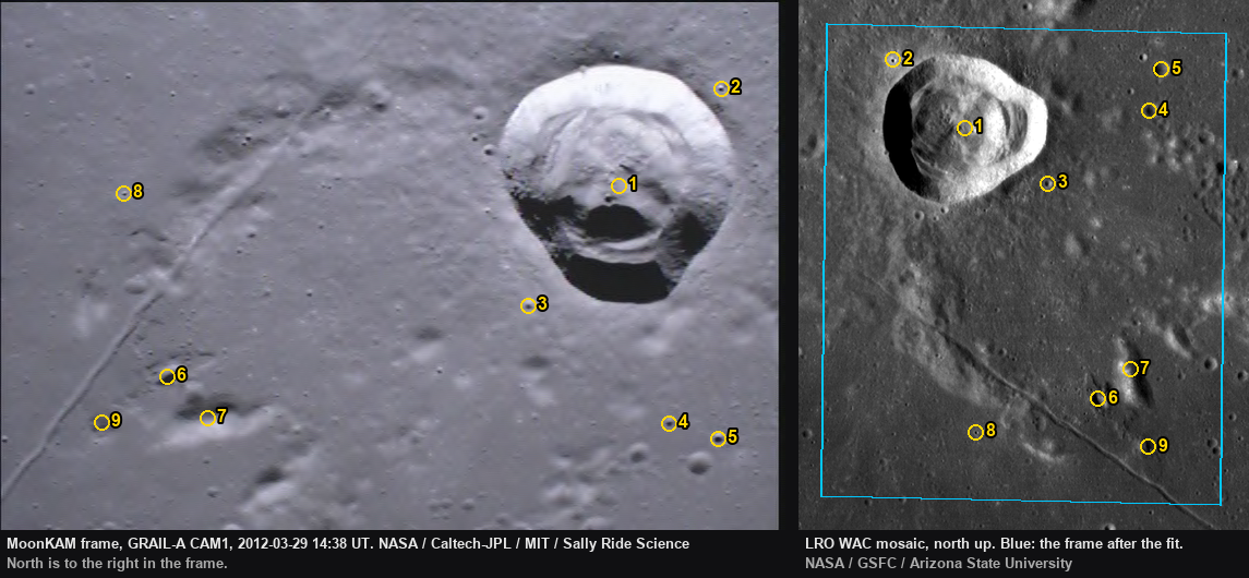
The original MoonKAM frame, before georeferencingSide by side: the frame with numbered control points, and the same points on the LRO WAC mosaic
On the map
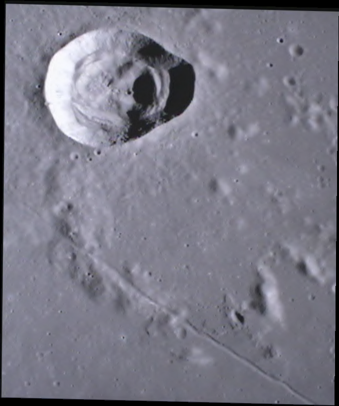
The warped frame on a plain longitude and latitude grid of the Moon.
Move over the map to read coordinates
Do it yourself, step by step
How this frame was placed on a map of the Moon by hand. You can repeat it in QGIS or ArcGIS Pro with the files on this page. Each step is one action.
What you need
The frame as an image: the original MoonKAM frame, before georeferencing, in the downloads below.
QGIS 3 (Layer menu, Georeferencer) or ArcGIS Pro (Imagery tab, Georeference).
The coordinate system "Moon (2015) - Sphere / Ocentric", code IAU_2015:30100. QGIS knows this code. In ArcGIS Pro, search the coordinate system list for "Moon".
Step 1. Choose a frame
Start from a set of MoonKAM frames sorted by date.
Skip frames that show black sky or a curved horizon. Those views are very tilted.
Skip frames with stripes, colored noise or blocks. Those are transmission errors.
Choose a frame with one large, clear feature, such as a crater with terraces.
Write down the date and time from the file name.
The file name GRAIL_A_CAM1_0WEY0WH100000_2012-089T14 38 20.494.bmp means GRAIL-A, camera 1, day 089 of 2012 (29 March), 14:38:20 UT.
Step 2. Find where the frame is
Look up where the spacecraft was at that time in JPL Horizons (https://ssd.jpl.nasa.gov/horizons/), with GRAIL-A (code -177) as the observer and the Moon as the target.
Note the point below the spacecraft. At 14:38:20 it was about 26.9 E, 8.9 N, about 45 km up, flying south.
Open the basemap around that point, about 5 degrees in each direction.
Look for a crater with the same size and shape as the crater in the frame.
Check at least 3 other features around it. Use their positions and sizes, not their shadows.
The spacecraft position is only a hint. The camera does not always point straight down. In this frame, Carrel is about 50 km north of the point below the spacecraft. The match comes from the shapes in the image.
What matched here: Carrel and its terraced inside wall, the ridge just south of it, the straight rille running south-east, a long mound with a dark pit at its north-west end, and a cluster of small craters east of Carrel.
Step 3. Work out which way is north
Find the shadow inside the big crater.
Find where the Sun was. On 29 March 2012 the Moon was near first quarter, so at 27 E the Sun was in the east.
Remember that the inside wall nearest the Sun is in shadow.
Turn the frame until the shadow is on the east side.
In this frame the shadow is at the bottom, so east is down and north is to the right. Rotate the frame 90 degrees counterclockwise to see it with north up.
The basemap is lit from the west, so its shadows fall on the opposite side. Do not match shadow to shadow.
Step 4. Place control points
Open the frame in the Georeferencer (QGIS), or add it to the map and click Georeference (ArcGIS Pro).
Set the target coordinate system to IAU_2015:30100.
Click the center of a feature in the frame.
Click the center of the same feature on the basemap.
Use crater centers, not crater edges. The center does not move when the light changes.
Spread the points over the whole frame, including the corners.
Place at least 6 points. We placed 9.
A control point joins one pixel in the frame to one longitude and latitude on the basemap. Our 9 points are in the table below.
You can skip the clicking and load our points. In QGIS, load the QGIS Georeferencer points file from the downloads. In ArcGIS Pro, import the control points table (CSV). Pixel x counts from the left edge, pixel y counts down from the top edge (QGIS writes y as a negative number).
Step 5. Fit and check
Choose the transformation "Polynomial 1" (QGIS) or "1st Order Polynomial (Affine)" (ArcGIS Pro).
Read the residual for each point in the table.
Find any point with a residual much larger than the others.
Check that point again on both images. Move it or delete it.
Stop when no single point stands out.
A first-order fit can move, turn, stretch and slant the frame, but it cannot bend it. Residuals of about 1 km here come from the tilted view, not from wrong points.
Step 6. Save the result
Set the resampling method to bilinear.
Set the output to GeoTIFF.
Run the georeferencing.
Add the new GeoTIFF over the basemap.
Set its transparency to 50 percent.
Check that Carrel and the rille line up with the basemap.
Our result covers about 26.22 to 27.59 E and 9.38 to 11.02 N. Compare yours with the georeferenced GeoTIFF in the downloads.
Control points and residuals
Point
Feature
Pixel
Longitude, latitude
Residual (frame pixels)
1
Center of crater Carrel
567.5, 170.5
26.7071, 10.6648
1.8
2
Small sharp crater north-west of Carrel
661.5, 81.5
26.4655, 10.8951
6.2
3
Small crater on Carrel's south-east flank
484.5, 280.5
26.99, 10.477
9
4
Crater B in the eastern crater cluster
613.5, 388.5
27.3321, 10.7228
15
5
Crater A in the eastern crater cluster
658.5, 402.5
27.3735, 10.8625
6.9
6
Dark pit at the north-west end of the long mound
153.5, 345.5
27.1591, 9.7459
11.4
7
Middle of the long bright mound
190.5, 383.5
27.2687, 9.8461
17
8
Isolated fresh crater south of Carrel
113.5, 177.5
26.7461, 9.6337
13.6
9
Small dark crater beside the rille
93.5, 387.5
27.3303, 9.5833
11.8
RMS error: 11.2 frame pixels, about 847 m. One frame pixel is about 75 m on the ground.
Limits
The view is tilted. MoonKAM looked at Carrel from the south at an angle, so the scale changes across the frame. Near the west and south-west edges, features can be 1 to 2 km off.
The points are hand-picked. Two people will click slightly different spots. The frame is also soft and compressed, so small craters are a few pixels wide.
The light is opposite. The frame is lit from the east and the basemap from the west, so craters look inside-out between the two. We used centers to avoid this.
The fit is first order. A second-order fit on the same 9 points gives about 530 m RMS, but with so few points it is easy to over-fit, so we kept first order. More points, or a camera model, would do better.
Height is ignored. Crater rims stand above the plain, and the tilted view shifts them. A flat sphere is assumed.
The basemap has its own errors. The WAC mosaic is accurate to roughly 100 m, which is small next to the fit error.
Treat the result as approximate: good for "where is this", not for measuring.
Technical notes
RMS error 11.2 frame pixels, about 847 m, over 9 control points (largest 17.0 px, 1236 m).
Approximate. MoonKAM frames are not taken straight down. This one looks back at Carrel from the south at an angle, so the scale changes across the frame. A first-order fit cannot remove that, so features near the west and south-west edges can be off by 1 to 2 km.
Control points were picked by eye, and the Sun lit the frame from the east while the mosaic is lit from the west, so shadows fall on opposite sides. Crater centers were used instead of shadow edges.
Location confirmed visually: crater Carrel with its terraced interior, the ridge to its south, the long straight rille running south-east, the elongated mound with a dark pit at its end, and the crater cluster east of Carrel all match the LRO WAC mosaic in position and size.
The spacecraft position (JPL Horizons, GRAIL-A about 45 km above 26.9 E, 8.9 N at this time) was used only as a hint for where to look.
For comparison, a second-order polynomial on the same points gives an RMS of about 534 m, but with 9 points and 6 terms per axis it has little check on itself, so the product uses the first-order fit.
The GeoTIFF is a Cloud-Optimized GeoTIFF with nodata 0 outside the frame; the PNG has no alpha so JMARS can load it.
A residual is how far a control point lands from where it should after the warp. Small residuals mean the points agree with each other; they do not prove the points were matched to the right craters. That is why this layer is labeled approximate.
One MoonKAM frame over crater Carrel, georeferenced by hand
GDAL reads the GeoTIFF CRS as Moon (2015) - Sphere / Ocentric, matching IAU_2015:30100, radius 1737400 m
GeoTIFF bounds (26.224, 9.382, 27.592, 11.018), size 684 x 818
Carrel center maps to 26.712 E, 10.666 N (Gazetteer 26.680 E, 10.666 N), output pixel row 175, col 243
GDAL reads the PNG world file: bounds (26.224, 9.382, 27.592, 11.018). GDAL does not read the .prj beside a PNG; QGIS and ArcGIS may ask for the CRS, so choose IAU_2015:30100.
Georeferenced from the original 720 x 486 BMP with a first-order polynomial (affine) fit to 9 hand-picked control points, warped with rasterio 1.5.2 / GDAL 3.12.2 on 2026-10-07
MoonKAM imagery credit: NASA / Caltech-JPL / MIT / Sally Ride Science.